
 DJI Airport 3, deployable in vehicles for unmanned operations
 PJC8 Comprehensive Smart Pipeline Detector
 Daqi Tiancheng SHARE505S PRO 51 Megapixel Medium Format Aerial Camera
 Sel S10 Portable 3D Laser Scanner
 GHJS12 explosion-proof portable 3D laser scanner
 S10 Real-Time 3D Laser Scanner
 DJI Airport 2+ Platform + AI Software
Product Details
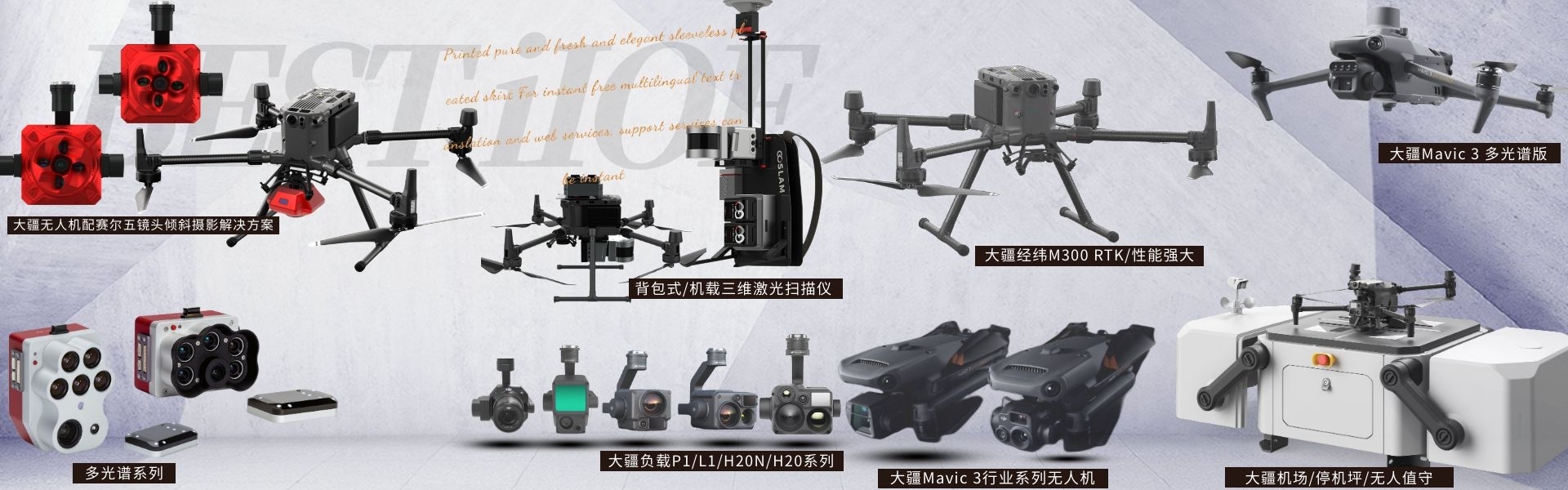
DJI drones and payloads, 3D laser scanners, ground-penetrating radar, multisp...


产品Price Negotiable
最小起订Quantity:1 Set 供货总Quantity: 20 Set


Dimensions |
|
Weight |
905 ± 5 grams |
System Power Consumption |
28 W (typical) / 58 W (max) |
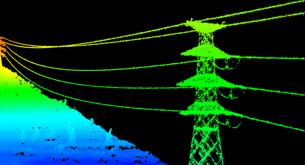
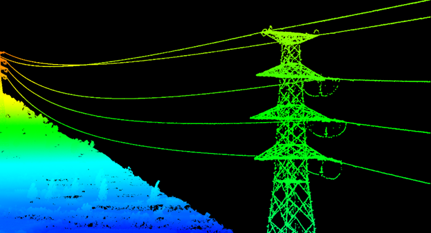
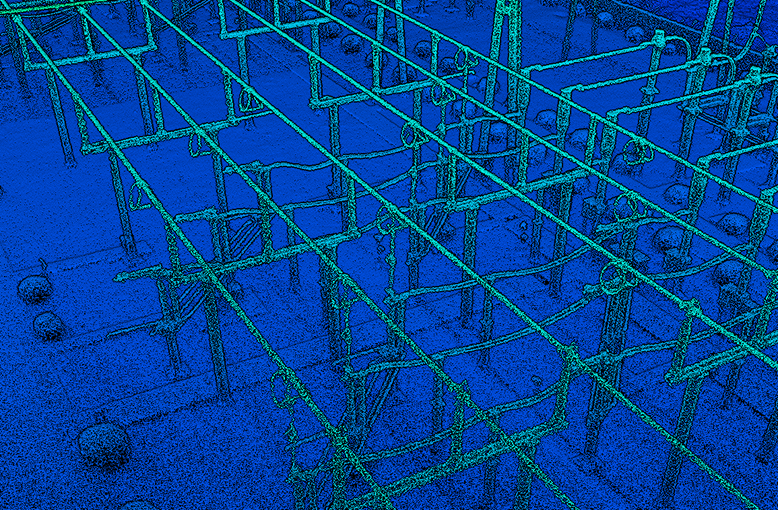
DJIM350 RTKEquipped with ZenithL2Laser Radar ApplicationsPower GridInspection ShenzhenPengjin Technology's Drone Technology Team, contact phone number18320930028 Miss Lai The company offers a variety of drones./Laser Radar / Oblique Photogrammetry / Multispectral / Hyperspectral and other loading solutions DJI releases the new generation of airborne high-precision laser radar Zenmuse Through technology improvements such as inertial navigation optimization, range enhancement, and spot size reduction, Zenith L2 delivers a dual enhancement of efficiency and quality for point cloud scanning of power grid transmission, transformation, and distribution equipment. To ensure mindfulness DJI's industrial applications have conducted extensive real-world business scenario tests of the excellent performance of the Zenmuse L2 in power grid point cloud modeling. This article will detail the testing conditions and compare them with the previous generation Zenmuse L1 product, exploring the value and advantages brought by the new Zenmuse L2 in power grid applications. DJI M350 RTK Equipped with ZenithL2 ZenithL2 Key enhancements for grid applications include: 1.Radar and Inertial Navigation Module Upgrade: Faster operational flight speed, enhanced efficiency110% 。 2. Inertial navigation system requires no preheating: No fear of scene change delays, start up and take off immediately, saving at least5 One-minute preheat time. 3. RangeL1 Enhance30%Ultra-high voltage and extra-high voltage transmission lines, a single scan can cover the sagged conductors at the arc drop, and restore the point cloud. 4. Operation Quality Report: Automatically generate quality reports, view operation effects on-site, and promptly retake and correct any issues on-site. 5. Supports DJI Enhanced Image Transmission: Utilizes carrier networks to overcome signal blockage issues, effectively extending the operational range of LiDAR. 6. Support for cloudPPKCollaborating with China Mobile, supportedPPK Match offline base station data for point cloud reconstruction, regardless of network availability or in flightRTK Disruptions, all operations can proceed smoothly for data collection. DJI M350 RTK with Zenmuse L2 DJIM350RTK equipped with Zenmuse L2 Grid application Efficiency Enhancement实测 In grid-based LiDAR point cloud collection, collection efficiency is a key performance indicator. For this reason, Zenith L2 incorporates an upgraded laser radar and inertial navigation module, enabling the drone to conduct operations and data collection at faster flight speeds. Please provide the Chinese content to be translated. For example, using a 220kV transmission line, we compared the performance of Zenith L1 and Zenith L2 in terms of flight speed. Previously, the typical flight speed of Zenith L1 was about 7m/s, and this time, we measured the collection performance of Zenith L2 at both 7m/s and when reaching high speed of 15m/s. Compare tower results, even with the drone's flight speed increased to At 15m/s, the point cloud results still meet the requirements. Due to the doubling of flight speed, the overall collection efficiency of Zenith L2 is estimated to have increased by approximately 110%. Quality Collection实测 In addition to improved efficiency, effective guarantee of point cloud quality is also necessary. Zen Thinking L2 features an upgraded light spot, measuring 4 x 12 cm (at a 100-meter flight altitude), which is only 20% the size of the Zenmuse L1. A smaller light spot aids in capturing more detailed models and can identify finer targets. For example, in this comparative test, we can see Zenith L2 offers a more refined tower restoration with fewer noise points. Additionally, we have also tested the modeling effects of distribution lines and substation, with significant improvements in point cloud models. Range verified Contemplation L2 Range up to 250 meters (reflectivity 10%, 100 klx), 450 meters (reflectivity 50%, 100 klx), typical operational altitude up to 150 meters, covering all power work scenarios. This test included a certain The 500kV cross-river transmission line and the 1000kV ultra-high-voltage line can be surveyed in one pass following typical operational procedures (flying above the towers, non-repetitive scanning), effectively addressing issues like wire breakage due to range limitations, and meeting the application requirements. Power Distribution Scene Field Test The outer diameter of the distribution wires is finer, requiring a higher precision in laser radar scanning. For lines perpendicular to the flight path (such as split lines), due to the larger spot size, only a small area of the line can be covered, with more of the light spots falling on the ground (as shown in the figure below). This results in the radar receiving more energy from the ground than from the lines, making it impossible to accurately display the line model. Illustration of LiDAR scanning spot (red ellipse indicates the spot) Zen thought L2 optimizes the spot size, which is only 20% of the size of Zenith L1. As a result, during distribution line scanning, even for split lines perpendicular to the flight path, the majority of the spot area can still cover the line, thereby enabling a better reproduction of the split lines. For pilots, there's no need to rotate drones along split routes; flying straight can still achieve successful collection, further enhancing the efficiency of power distribution collection. Transformer Substation Field Test This test also involves a certain The 220kV substation underwent point cloud collection testing. Thanks to improvements like spot optimization, Zenith L2 can provide high-quality point cloud results for the substation's equipment details (such as isolators, transformers, porcelain bottles, etc.). These point cloud models can directly plan drone inspection routes for the substation. Summary DJI Zenmuse Series L2 delivers dual enhancements in efficiency and quality for power scenarios. With the assistance of upgraded laser radar and inertial navigation modules,L2 achieves a doubling in line collection efficiency. Additionally, the smaller light spot is widely applicable for point cloud collection in various power scenarios such as transmission, transformation, and distribution. Thymios L2 brings a new solution for autonomous drone inspections and data collection for the digital transformation of power grids. DJIM350 RTKEquipped with ZenithL2Laser Radar ApplicationsPower GridInspection ShenzhenPengjin Technology's Drone Technology Team, Contact Phone18320930028 Miss Lai The company offers a variety of drones./Laser Radar / Oblique Photogrammetry / Multispectral / Hyperspectral and other loading solutionsCase


Phone Consultation
QQ Service